Wilderness boundary facts vs. un-facts
(after being called “criminal”)
Everyone knows the internet is full of mis-information. And that mis-information is often passed on via social media. Having a gap in one’s knowledge, “simple ignorance”, becomes “damn ignorance” when that gap is filled with incorrect assumptions, or even made-up “facts”, and posted to the web as factual without any attempt to question or verify, spreading still more mis-information.
A example was recently posted on Instagram, claiming Big Sur Trailmap (and so me) publishes incorrect wilderness boundary lines, calling this “criminal”. The “proof” was this map (fyi rotated with North on left, without any map attribution)
Instagram image 1
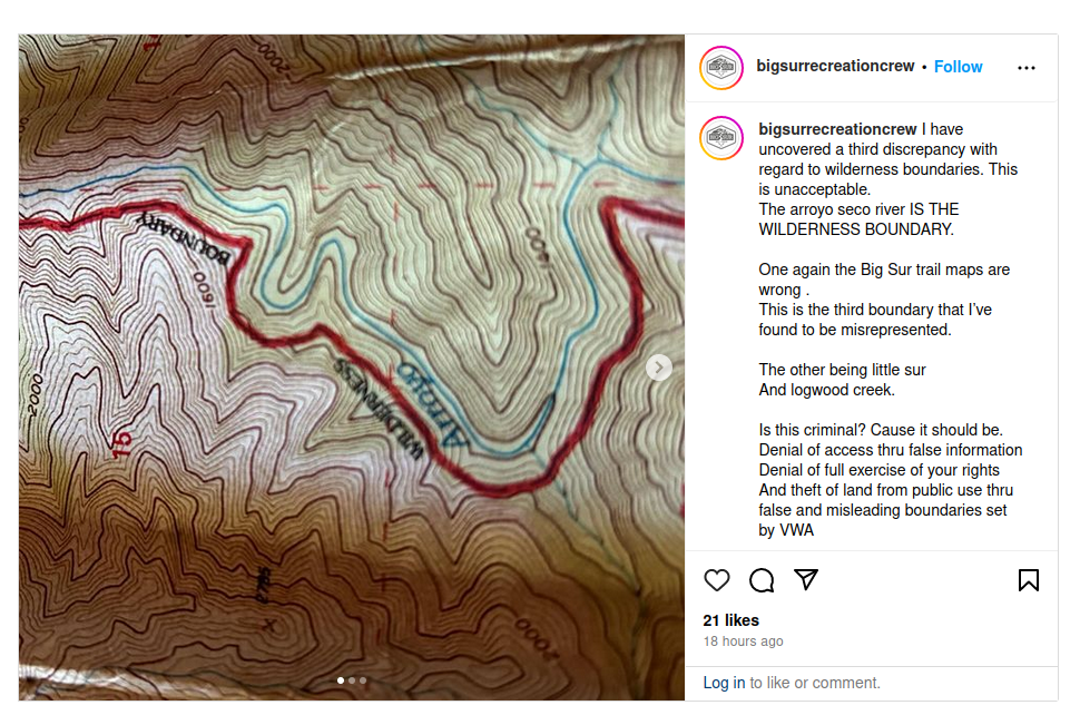
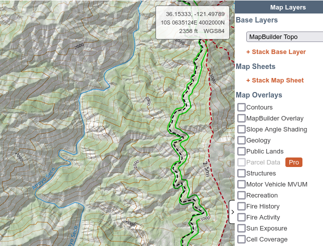
showing a wilderness boundary along the west edge of Arroyo Seco river, whereas the edge of my “gold” (yellow) “wilderness” overlay instead follows a narrow wilderness corridor along ArroyoSeco-Indians Road – see below
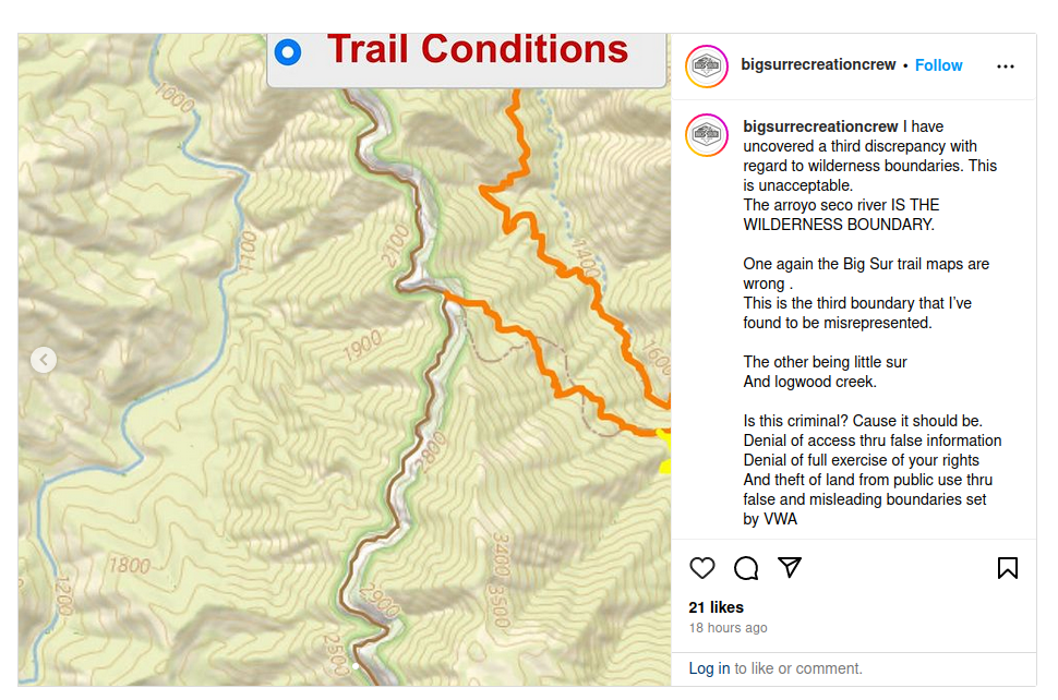
Instagram image 2
Definitely disappointed that no attempt was made to ask me about Big Sur Trailmap’s boundary lines, to get any clarifying info. Or look at reliable data elsewhere on the web, such such as CalTopo. Instead, without any fact checking, it’s assumed Big Sur Trailmap is purposely deceiving – so a post and rant is made about how I am “criminal”, with bile, etc. (And these are ‘boundaries set by VWA’ ![]() – it’s a conspiracy!) Bizarre to read that my promulgation of official US wilderness data is “criminal” – when the real problem is the poster’s own lack of knowledge and and map interpretation failures, not any error on my map.
– it’s a conspiracy!) Bizarre to read that my promulgation of official US wilderness data is “criminal” – when the real problem is the poster’s own lack of knowledge and and map interpretation failures, not any error on my map.
THE FACTS
The Big Sur Trailmap gold (yellow) “wilderness” overlay is based on wilderness boundary points taken from current government databases. (See “DETAILS” below for details.)
FACT #1: out-of-date map
The map used in the post is out-of-date. In the original ‘Endangered American Wilderness Act’ of 1978 the boundary did follow Arroyo Seco for awhile, but the ‘Big Sur Wilderness and Conservation Act’ of 2002 changed that into a narrow corridor on each side of ArroyoSeco-Indians Road. (Giving wilderness protection to Arroyo Seco, a good thing IMHO.)
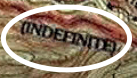
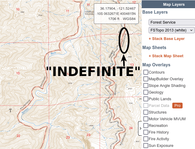
FACT #2: believing an “INDEFINITE” line
The “wilderness boundary” on that old map was not even an official line back when the map was made. If you follow it around, you find “INDEFINITE” in many places. Two are shown below, with the same region as used in the post:
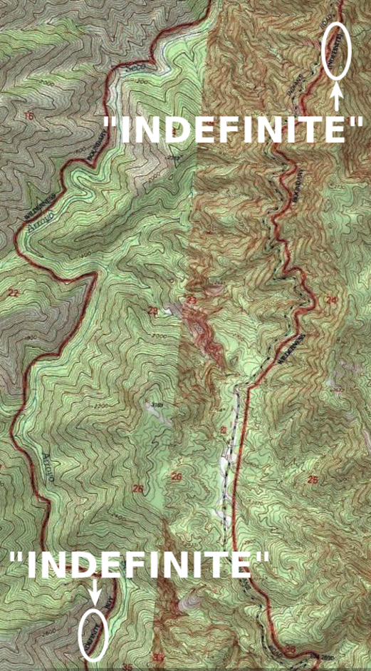
The “INDEFINITE” marking was put there for a reason !
FACT #3: USGS map validates Big Sur Trailmap
Instagram image 2 above, showing a Big Sur Trailmap with ‘USGS Topo + Wilderness’ background, has its own intrinsic validation if you read the map correctly. Note how the edge of my gold overlay matches the green line. That green line does not come from me, it comes from the underlying USGS topo map, marking the wilderness boundary as set by the USGS. (If you use the ‘USGS Topo’ background, the gold overlay disappears but the green line remains.) So the USGS wilderness boundary data validates my overlay edge.
USGS Topo + wilderness

USGS Topo
(FYI that USGS background map is the current “National Map”, not the now out-of-date USGS quadrangle maps. Also, USGS green lines are generic boundary lines, so elsewhere on map can indicate property lines, national forest boundaries, etc.)
FACT #4: other Internet data
Other websites also provide wilderness boundary data. You can check out CalTopo’s default ‘Map Builder’ background which uses green wilderness boundaries. You’ll find agreement with my wilderness lines as a narrow non-wilderness corridor.
Of course incorrect wilderness maps can also be found on the internet. For example, CalTopo has a “Forest Service – 2013” map which does not have a narrow ArroyoSeco-Indians Road corridor (also with “INDEFINITE” along its wilderness boundary lines). A good example of incorrect info appearing on the web, since supposedly dated ‘2013’ but with a line invalidated by the 2002 Act.
SUMMING UP
Wilderness boundary lines are certainly incorrect on some maps. But the poster himself was the one using an out-of-date map. And using lines marked on the map as being unofficial (and ultimately incorrect). And not bothering to do any further investigation before spreading mis-information on the web.
Big Sur Trailmap focuses on current info about trails. Inserting new boundary line data is time-consuming and a PITA, with lots of pieces to keep track of – so done only if I know of a change or error. As of this post, I know of no errors.
If I do learn of a change or error, I will make corrections. But just hearing about a supposed change is not enough – the trustworthiness of the source and other available info must be considered. Lots of snap judgements and mis-information flying around out there !
DETAILS – Big Sur Trailmap wilderness boundaries
Wilderness boundaries are set by acts of Congress, which publish the lawful boundaries. The first wilderness boundaries were created by the Endangered American Wilderness Act of 1978.
They are amended from time to time – for example, the Big Sur Wilderness and Conservation Act of 2002 made several additions to the original Ventana wilderness. (The VWA was instrumental in this process.)
Also, wilderness boundaries can change without a formal act of congress. Notably, inholdings (private ownership inside National Forest) are excluded from wilderness areas – so if an inholding’s legal boundary changes, or is transferred to the government, that automatically changes the wilderness boundary.
The congressional bills contain legal descriptions. Turning those into lat/lon points to be used on maps, etc. depends upon government agencies. Wilderness boundaries can be found in both USGS (U.S. Geological Survey) and USFS (U.S. Forest Service) databases – but translating legal descriptions is tricky and the the lines from the different agencies do have some differences, mostly minor.
Big Sur Trailmap uses digital lat/lon boundary data obtained from USGS/USFS servers, which are then converted to lines or shapes displayed on a background map. I know of two minor errors in the USFS wilderness boundary data, both of which are correct in the USGS data – so in the main my wilderness boundary lines use the USGS data. However, I also know of one error in the USGS data (an inholding boundary has been formally changed by the USFS and not yet known to USGS), so my wilderness overlay follows the USFS data there.