Trailwork with friends, bypassing the “Apex of Brushiness” and lots of photos of brush (with Paul Danielson, Maria Ferdin, and Burke Siedhoff)
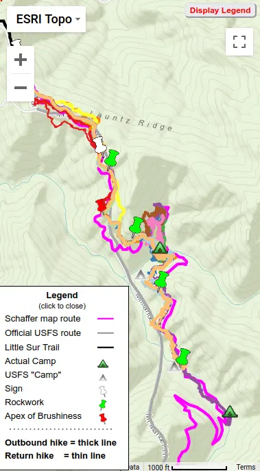
Hike 3 = Yellow
Launtz Creek Camp having been “found”, Paul Danielson and I wanted to bring some friends out, to show them the trail and camp – and to get additional help clearing the trail. So eight months later, January 2013, we arrived at Pico Blanco Scout Reservation along with Maria Ferdin (a founder of Monterey Bay Area Hiking Group and frequent hiking companion of mine) and Burke Siedhoff (a grand old hiker always brimming with enthusiasm).
A certain Big Sur habitant, having a long history of venomous verbal attacks on others and whom I will call “JB” aka BigSurRecCrew, sent me this email Tuesday morning a week after Labor Day:
Extravagant flagging, an unhappy couple, Launtz Creek Camp is “found” but have to shortcut trail (with Paul Danielson)
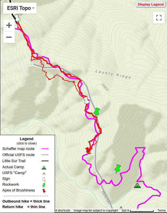
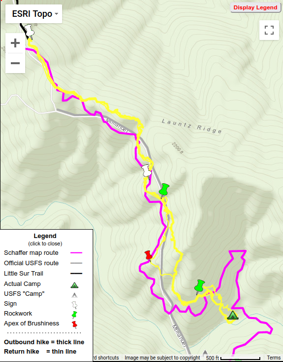
Hike 2 = Orange
Over a year after our first hike, in March of 2012 Paul Danielson and I decided to re-visit the “lost” Mount Manuel Trail – to go beyond the ‘Apex of Brushiness’ which had stopped our last hike and hopefully reach, and so “find”, Launtz Creek Camp. This turned out to be the most interesting hike of my 11 hikes “finding” the Mount Manuel trail.
Little tread, much brush, give up at “Apex of Brushiness”
Find sign and rockwork, Paul follows deer track
(with Paul Danielson)
Hike 1 = Red
February 2011 found myself and Paul Danielson, who had introduced me to the wonders of hiking old trails in the Ventana Wilderness, at Pico Blanco Boy Scout Camp. We’d obtained permission and gate access, but were warned the dirt road was very rough as not worked on since summer. Indeed it was – I needed the 4WD of my Xterra, newly bought for just such places. Being my first time there, the camp’s setting under tall stately redwood trees with nearby creek was very impressive and peaceful.
Of the “lost” trails I GPS’d, the north end of the Mount Manuel Trail took more effort than any other. And in the end, was the one trail not completely mapped when foot problems prevented further work. In several sections the route went over steep slopes from which all tread had eroded and no trail clues could be found. In all, I made 11 hikes there between 2011 and 2016 looking for traces and clues (while aging from 65 to 70).
Wilderness boundary facts vs. un-facts (after being called “criminal”)
Everyone knows the internet is full of mis-information. And that mis-information is often passed on via social media. Having a gap in one’s knowledge, “simple ignorance”, becomes “damn ignorance” when that gap is filled with incorrect assumptions, or even made-up “facts”, and posted to the web as factual without any attempt to question or verify, spreading still more mis-information.
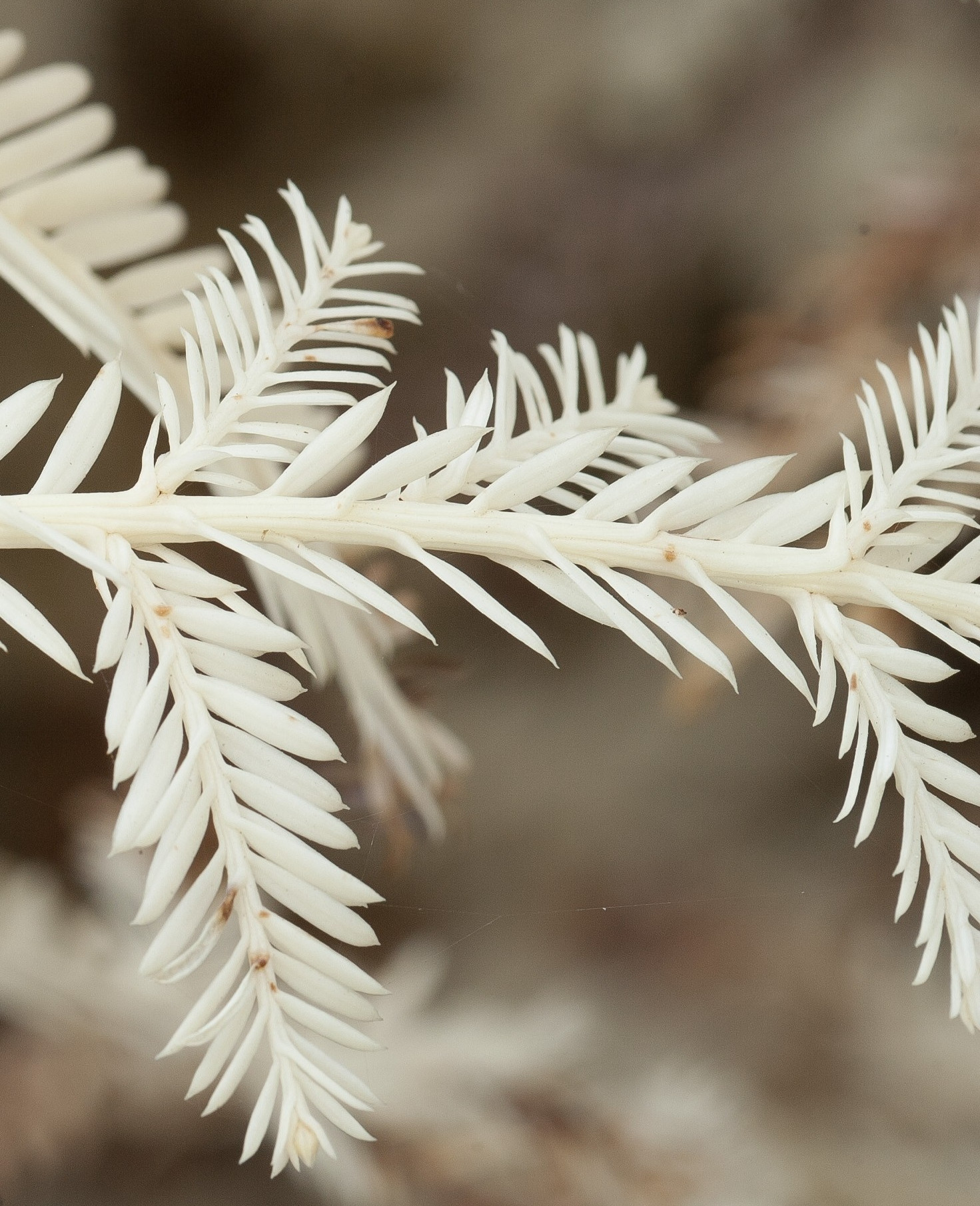
I doubt you’ve seen a white plant. “Plants” (here used in the “strict sense”, aka Viridiplantae, which excludes fungii among others) use green chlorophyll to produce the energy they need to grow and thrive.
In 2005 Wilderness Press (“WP”) produced the first sheet map available for the backcountry Big Sur trails – before that, hikers had to depend upon upon quadrangle maps with their many drawbacks. I first used that WP map when exploring the Ventana Wilderness and always liked its very clean and readable format, with trail lines clearly displayed atop contour lines.
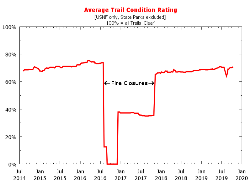
Nature is relentlessly degrading the National Forest trails in Big Sur. And the US Forest Service no longer maintains them. So volunteer trailcrews have been pushing back – lopping, sawing, and doing treadwork to keep the trails passable. But are they rebuilding the trails as fast as nature is destroying them??
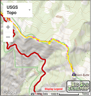
Many don’t realize that Black Butte is the fifth highest peak in the Ventana (and in Monterey County), only 35 ft lower than South Ventana Cone. In fact, some have not even heard of Black Butte! Yet the views from there are magnificent – the summit is narrow, so gives a 360° panorama from a 4936 ft elevation.
 Hike 3 = Yellow
 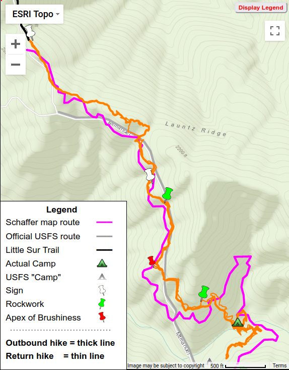 Hike 2 = Orange