
In 2005 Wilderness Press (“WP”) produced the first sheet map available for the backcountry Big Sur trails – before that, hikers had to depend upon upon quadrangle maps with their many drawbacks. I first used that WP map when exploring the Ventana Wilderness and always liked its very clean and readable format, with trail lines clearly displayed atop contour lines.
But the WP map did have errors, some egregious. Notable was a trail line heading west from the Ventana Double Cone. Such has never existed (though some have bushwhacked that route) – instead, it is mostly heavy brush. The WP map also displayed a long overgrown “lost” trail west of that – which almost connected to the false trail, unfortunately leading some to think that with a short bushwhack between then a nice loop hike could be made. Paul Danielson and I ran into one such backpacker when camped at Hiding Canyon Camp – he had come in along the Pine Ridge Trail and planned to complete a loop over the false and “lost” trail route. We advised that would be through heavy brush in steep terrain with no followable path – and suggested he return the way he came. He was reluctant to accept that, since he’d already come 2/3 of the way around his loop and had a plane to catch so under time pressure. We never saw him again and I’ve wondered what happened, which route he opted to take and the result.
Despite its deficiencies, the WP map was “better than nothing” – since the only alternative was bulky and hard to use USGS quadrangle maps. And many of the WP map errors became common knowledge, so experienced Big Sur hikers were not misled by them.
Then in 2012, while shopping at REI Marina I spied a new Big Sur map! Created by National Geographic(“NatGeo”) !! Quite a surprise since there’d not been any promotion. Of course I immediately bought one to examine. You are likely familiar with the NatGeo map format, very colorful with high-quality printing. That’s nice, but I wanted to know how it compared to the WP map in coverage and accuracy. And a first glance quickly found big problems.
In the Ventana Wilderness the most heavily used trail has been the Pine Ridge Trail – and the most used camp along it, by far because of its hot spring, is Sykes Camp (it’s hard to explain the extent of Sykes’ legendary/infamous reputation in central California – but for example, it has a Yelp page!). Egregiously, NatGeo’s map had three camps along the Pine Ridge Trail all mis-located – including Sykes Camp itself.
And I immediately realized what had happened. When beginning my own trail mapping in 2009 I first got the latest USFS data from their GIS person in Goleta, the National Forest headquarters, as a basis to start from. I knew it would have errors, but not the extent nor which trails or camps were problematic. I quickly found some obvious errors without needing any field checking. The worst of those were three camps along Pine Ridge Trail incorrectly placed/labeled. The Sykes Camp misplacement in particular was important, so I sent an email back to Goleta to report those errors. I never got a response.
So now, in 2012, I realized NatGeo must have gotten that bad camp data from the USFS and used it for their map. And of course the map also included all the other errors of the USFS data.
I sent an email to National Geographic, to inform them of major errors in their map. I also suggested they talk to people with local knowledge if they wanted to know where the trails and camps really were. NatGeo contacted the Ventana Wilderness Alliance (“VWA”). They told me that NatGeo wanted to know if I knew what I was talking about! That contact connected two acquaintances who facilitated cooperation and eventually the VWA brought some locals together to examine the NatGeo map and provide corrections.
(click for larger image)
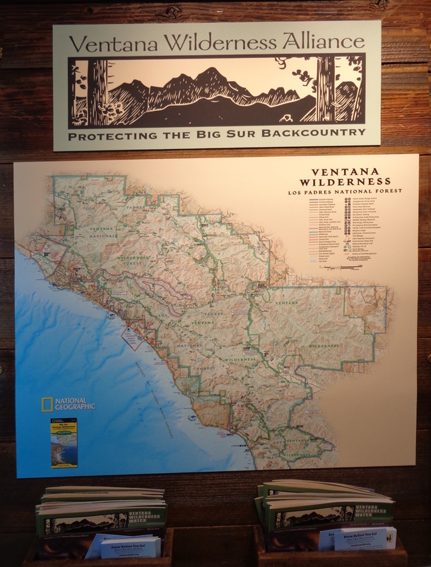
To their great credit, NatGeo recalled all their original maps from stores. Later they send out a revised version, based on the VWA input. That map is largely accurate in what it presents (a few trails are mislocated, but not too badly – and “use” trails are generally excluded.).
In return for the help provided, NatGeo produced a nice display promoting the VWA (and their map, of course) which is now on display in the Marina REI store. Whenever I look at it I am reminded of the shock I felt when seeing the misplaced camps on the original version.
I still have the original map I bought in 2012, as an example of how maps can sometimes be badly inaccurate. And, in this day of multiple map apps, as a reminder that accuracy of the underlying data is more important than a “cool” presentation.
[For my review of the four currently available Big Sur sheet hiking maps, see Printed Maps for Big Sur Hikers]